Gathering the gems worth your time…
Destination guide
Ha Giang
Vietnam
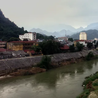
Hà Giang is a city in the northeast region of Vietnam, on the banks of the Lô River. The surrounding Hà Giang Province impresses visitors with its high karst plateau, steep hills, winding roads, and ethnic diversity.
At a glance
- Best time to go
- November–December
- Getting around
- Motorbike
- Vetted picks
- 16 places to see, do, eat, and stay
- Real coverage
- 6 vetted creator sources
How these 16 picks are sourced
15 of 16 are named by a second, independent source — Vietnam Tourism (vietnam.travel), Lonely Planet and Vietnam Tourism, and 3 others — and each card names its own. The remaining 1 rest on the reference article alone: we list them because Wikivoyage or Wikipedia documents them, not because anyone else vouched for them. We also watched 6 creator videos, 3 of them from local channels rather than visiting ones. 1 of the 16 descriptions are quoted word for word from Wikivoyage under CC BY-SA rather than written by us — each of those cards says so. What we add is the checking, the corroboration above, and the choice of which places are worth your time at all.What we can't promise is that it's still true. Venues close, hours and prices change, and we don't re-check them — a place here closed for good and sat on this page for a year before anyone noticed. The insights are AI-written from these sources and can be wrong too. Confirm anything you'd be sorry to be wrong about before you set out. Terms.
Watch first
Ranked by views and how well each landed with the people who watched it, judged against the other coverage of this place — plus a local creator where we found one.

Hướng dẫn đi phượt Hà Giang bằng xe máy năm 2023 - Siêu chi tiết - Cập nhật tuyến đường mới!
TADA Vlog - Từ A Đến Á - Travel & Food · 272K viewsLocalvi

Ha Giang Loop in Vietnam - The Ultimate Guide
Arjay Neyra · 21K views
![Siêu Chi Tiết Phượt Đèo Mã Pì Lèng Hà Giang - Phượt Tây Đông Bắc tập 8 [4K]](https://i.ytimg.com/vi/mo0AXNC-R0U/hqdefault.jpg)
Siêu Chi Tiết Phượt Đèo Mã Pì Lèng Hà Giang - Phượt Tây Đông Bắc tập 8 [4K]
Thanh Freeman · 7K viewsLocalvi

HA GIANG LOOP ULTIMATE GUIDE 🇻🇳 everything you need to know
Claire Hawkins · 23K views

Kinh Nghiệm Du Lịch Hà Giang Tự Túc Chi Tiết Nhất Cho Người Mới Từ A - Z | Tico Travel
Lalago · 4K viewsLocalvi

Ha Giang Loop | Everything To Know Before You Go
wanderlost · 6K views
Best time to go
Best window: November–December
May, June, July, August and September are the months to avoid — very heavy rain. The window below is when it is genuinely pleasant.
Jan
Feb
Mar
Apr
May
Jun
Jul
Aug
Sep
Oct
Nov
Dec
IdealGoodOkayOff-season
Rated from ten years of daily temperature and rainfall recorded at this destination, via Open-Meteo's ERA5 reanalysis. Hover a month for its real numbers.
Getting around
By motorbike
A common price is 150,000 dong/day for a semi-automatic bike (110cc). You can find several rentals in Ha Giang. Some of them run out of motorbikes, but booking in advance is not necessary. It's better to have a look at the bike before renting.
Transport notes from Wikivoyage, CC BY-SA 4.0.
What to see
Places are listed from Wikivoyage and our own sourced research. Worth it means a second, independent source names the place too; “3 sources agree” means three or more do — and each card names them, so you can check. Single source means the opposite, said plainly: the reference article lists it and nothing else we checked does.
Quan Ba Heaven's Gate
Worth itAlso recommended by Lonely Planet
Stop at the pass overlooking the Twin Mountains and valley below, a classic first viewpoint on the Ha Giang Loop.
Vetted sources
Lung Cu Flag Tower
Worth itAlso recommended by Lonely Planet
Climb to Vietnam's northernmost flag tower for views over the karst plateau near the Chinese border.
Vetted sources
Mã Pí Lèng Pass
Worth itAlso recommended by Vietnam Tourism (vietnam.travel)
Called 'arguably the most mind-blowing stretch of road in all of Vietnam', this pass between Đồng Văn and Mèo Vạc drops sheer cliffs to the emerald Nho Quế River far below, cut by hand by volunteers in the 1960s.
Vetted sources
Lũng Cú Flag Tower
Worth itAlso recommended by Vietnam Tourism (vietnam.travel)
A 30m tower marking Vietnam's northernmost point near the Chinese border; climbing almost 400 steps to its base and 140 more inside rewards visitors with 360-degree views across the karst plateau into China.
Vetted sources
Đồng Văn Karst Plateau
Worth itAlso recommended by Vietnam Tourism (vietnam.travel)
A UNESCO Global Geopark of dramatic grey limestone peaks and rocky valleys that defines the loop's high-altitude second half, formed from ancient seabed uplifted over 400 million years.
Vetted sources
Đồng Văn Old Quarter
Worth itAlso recommended by Vietnam Tourism / Odynovo Tours
A cluster of century-old stone houses and narrow lanes built by Hmong and Chinese traders; at night the central square fills with music and lantern light, a quieter counterpoint to the loop's mountain roads.
Vetted sources
Hmong King's Palace (Dinh Vua Mèo)
Worth itAlso recommended by Vietnam Tourism
Built 1898-1907 for Hmong chieftain Vương Chính Đức at a cost of 150,000 silver piastres, this fortified mansion in Sa Phìn blends Chinese, French and Hmong architecture and is protected as a Vietnamese National Relic.
Vetted sources
Heaven's Gate Pass (Cổng Trời Quản Bạ)
Worth itAlso recommended by Vietnam Tourism (vietnam.travel)
The gateway into Ha Giang's highlands, framing a first view over the Quản Bạ valley and the twin 'Fairy Bosom' peaks, and marking where the loop's dramatic mountain scenery begins in earnest.
Vetted sources
Mã Pí Lèng River Gorge
Single sourceThere are small tour boats here. The Mã Pí Lèng Pass above lies at an elevation of 1,500 meters.
Description quoted from Wikivoyage, CC BY-SA
Vetted sources
What to do
Ma Pi Leng Pass
Worth itAlso recommended by Lonely Planet
Ride the 20-kilometre stretch of switchbacks threading between limestone towers above the emerald Nho Que River, the loop's most scenic section.
Vetted sources
Nho Quế River boat trip, Tu Sản Canyon
Worth itAlso recommended by Vietnam Coracle
An hour-long boat ride from Ta Lang Wharf near Đồng Văn through Tu Sản Canyon, reputed to be Asia's deepest canyon, gliding beneath karst walls that tower up to 800m above the emerald water.
Vetted sources
Dốc Chín Khoanh (Nine-Turn Pass)
Worth itAlso recommended by Vietnam Tourism (vietnam.travel)
A hairpin descent of nine tight switchbacks into the valley below Quản Bạ, one of the loop's signature stretches of road for motorbike riders navigating steep, curving mountain terrain.
Vetted sources
What to eat
Đồng Văn Sunday Market
Worth itAlso recommended by Vinpearl Travel Guide
A weekly market (5am-1pm every Sunday) in Đồng Văn's old quarter where Hmong, Tay and Dao traders sell corn wine, textiles and produce, giving travellers a rare, unstaged look at highland commerce and food.
Vetted sources
Thắng cố stalls, Mèo Vạc
Worth itAlso recommended by Vietnam Tourism
Mèo Vạc is a traditional stop for thắng cố, the Hmong horse-and-offal stew simmered for hours in a communal pot, traditionally eaten at highland markets alongside locally distilled corn wine.
Vetted sources
Quản Bạ Market
Worth itAlso recommended by Vietnam Tourism
A highland market on the loop's first stretch known for its corn wine, fresh mountain vegetables and handwoven textiles, offering an early taste of the ethnic-minority food culture the loop is built around.
Vetted sources
Tam Sơn
Worth itAlso recommended by Vietnam Tourism (vietnam.travel)
A lunch stop on Day 1 of the loop set among jutting forested karst hills, serving northern Vietnamese highland cuisine and giving riders their first rest after crossing Heaven's Gate.
Vetted sources
Build your day
Pick the places you want in Ha Giang, Vietnam and we will put them on a map in an order that does not cross the city twice.
Where to next
Nearby cities in Vietnam we’ve vetted too.
- SapaTerraced rice paddies climb the slopes below Fansipan, Indochina's highest peak, through Hmong and Dao villages.
- HanoiVietnam's capital wraps a thousand-year-old Old Quarter around bun cha stalls now covered by Michelin's Vietnam guide.
- Ninh BinhKarst valleys and rice paddies traversed by sampan boat through Tam Coc, dubbed 'Ha Long Bay on land'.
- Ha Long BayNearly 2,000 limestone karsts rise from emerald water, best seen from an overnight cruise junk boat.